Surveyor
Summary
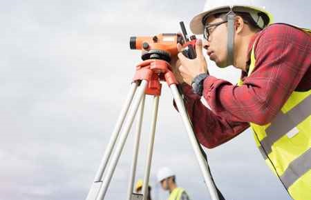
Surveyors make precise measurements to determine property boundaries.
What they do
Surveyors provide data relevant to the shape and contour of the Earth’s surface for engineering, mapmaking, and construction projects.
They typically do the following:
- Measure distances and angles between points on, above, and below the Earth’s surface
- Travel to locations and use known reference points to determine the exact location of important features
- Research land records, survey records, and land titles
- Look for evidence of previous boundaries to determine where boundary lines are located
- Record the results of surveying and verify the accuracy of data
- Prepare plots, maps, and reports
- Present findings to clients and government agencies
- Establish official land and water boundaries for deeds, leases, and other legal documents and testify in court regarding survey work
Surveyors mark and document the location of legal property lines. For example, when a house or commercial building is bought or sold, surveyors may mark property boundaries to prevent or resolve disputes. They use a variety of measuring equipment depending upon the type of survey.
When taking measurements in the field, surveyors make use of the Global Positioning System (GPS), a system of satellites that locates reference points with a high degree of precision. Surveyors use handheld GPS units and automated systems known as robotic total stations to collect relevant information about the terrain they are surveying. Surveyors then interpret and verify the results on a computer.
Surveyors also use Geographic Information Systems (GIS)—technology that allows surveyors to present spatial information visually as maps, reports, and charts. For example, a surveyor can overlay aerial or satellite images with GIS data, such as tree density in a given region, and create digital maps. They then use the results to advise governments and businesses on where to plan homes, roads, and landfills.
Although advances in surveying technology now allow many jobs to be performed by just one surveyor, other jobs may be performed by a crew, consisting of a licensed surveyor and trained surveying technicians. The person in charge of the crew, known as the party chief, may be either a surveyor or a senior surveying technician. The party chief leads day-to-day work activities.
Surveyors also work with civil engineers, landscape architects, cartographers and photogrammetrists, and urban and regional planners to develop comprehensive design documents.
The following are examples of types of surveyors:
Boundary or land surveyors determine the legal property lines and help determine the exact locations of real estate and construction projects.
Engineering or construction surveyors determine the precise location of roads or buildings and proper depths for building foundations. They show changes to the property line and indicate potential restrictions on the property, such as what can be built on it and how large the structure can be. They also may survey the grade and topography of roads.
Forensic surveyors survey and record accident scenes for potential landscape effects.
Geodetic surveyors use high-accuracy technology, including aerial and satellite observations, to measure large areas of the Earth’s surface.
Marine or hydrographic surveyors survey harbors, rivers, and other bodies of water to determine shorelines, the topography of the floor, water depth, and other features.
Mine surveyors survey and map the tunnels in an underground mine. They survey surface mines to determine the volume of materials mined.
Work Environment
Depending on the specific job duties, surveying involves both fieldwork and office work. Fieldwork involves working outdoors in all types of weather, walking long distances, and standing for extended periods while taking measurements. Surveyors sometimes climb hills with heavy packs of surveying instruments. When working near hazards such as traffic, surveyors generally wear brightly colored or reflective vests so they may be seen more easily. When working in underground mines, surveyors work in enclosed spaces.
Traveling is often part of the job, and surveyors may commute long distances or stay at a project location for an extended period of time. Those who work on resource extraction projects may work in remote areas and spend long periods away from home.
How to become a Surveyor
Surveyors typically need a bachelor’s degree. They must be licensed before they can certify legal documents and provide surveying services to the public.
Surveyors typically need a bachelor’s degree because they work with sophisticated technology and math. Some colleges and universities offer bachelor’s degree programs specifically designed to prepare students to become licensed surveyors. Many states require individuals who want to become licensed surveyors to have a bachelor’s degree from a school accredited by ABET. A bachelor’s degree in a closely related field, such as civil engineering or forestry, is sometimes acceptable as well. An associate degree may be sufficient in some cases with additional training.
In order to become licensed, most states require approximately 4 years of work experience and training under a licensed surveyor after obtaining a bachelor’s degree. Other states may allow substituting more years of work experience and supervised training under a licensed surveyor in place of education.
In some states, surveying technicians can become licensed surveyors after working for as many as 10 years under a licensed surveyor. The amount of work experience required varies by state. Check with your state for more information.
All 50 states and the District of Columbia require surveyors to be licensed before they can certify legal documents that show property lines or determine proper markings on construction projects. Candidates with a bachelor’s degree usually must work for several years under the direction of a licensed surveyor in order to qualify for licensure.
Although the process of obtaining a license varies by state, the National Council of Examiners for Engineering and Surveying has a generalized process of four steps:
- Complete the level of education required in your state
- Pass the Fundamentals of Surveying (FS) exam
- Gain sufficient work experience under a licensed surveyor
- Pass the Principles and Practice of Surveying (PS) exam
Most states also have continuing education requirements for surveyors to maintain their license.
Pay
The median annual wage for surveyors was $63,420 in May 2019. The median wage is the wage at which half the workers in an occupation earned more than that amount and half earned less. The lowest 10 percent earned less than $36,110, and the highest 10 percent earned more than $104,850.
Job Outlook
Employment of surveyors is projected to grow 2 percent from 2019 to 2029, slower than the average for all occupations.
Surveyors will continue to be needed to certify boundary lines, work on resource extraction projects, and review sites for construction. However, the use of drones and other technologies is expected to increase worker productivity and may therefore limit employment growth.
Similar Job Titles
City Surveyor, County Surveyor, Land Surveyor, Mine Surveyor, Registered Land Surveyor, Surveyor
Related Occupations
Geodetic Surveyor, Environmental Engineering Technologist and Technician, Surveying and Mapping Technician, Conservation Scientist, Environmental Science and Protection Technician (including Health)
More Information
The trade associations listed below represent organizations made up of people (members) who work and promote advancement in the field. Members are very interested in telling others about their work and about careers in those areas. As well, trade associations provide opportunities for organizational networking and learning more about the field’s trends and directions.
- American Association for Geodetic Surveying
- American Society for Photogrammetry and Remote Sensing
- American Society of Civil Engineers
- Geographic and Land Information Society
- National Association of County Surveyors
- National Society of Professional Surveyors
Magazines and Publications
- Point of Beginning Magazine
- The American Surveyor
- Civil and Structural Engineer Magazine
- xyHt Magazine
Whether the project is measuring the depth needed for a skyscraper’s foundation or mapping backyard boundaries, a surveyor steps in to get the lay of the land. Surveyors use sophisticated technology to take precise measurements of the Earth’s surface for maps and construction projects. They prevent—or help to resolve— boundary disputes for both home and business owners by documenting legal property lines, and helping determine the exact locations of real estate and building projects. During construction, surveyors determine the precise location of roads or buildings and proper depths for building foundations. They conduct research on land records and titles to show changes to a property line, and report on restrictions, such as the type and size of structures that may be built on a property. Most surveyors work for surveying or engineering companies; some work in construction or for government offices. Although surveyors spend time in offices, fieldwork is essential, and often involves standing for extended periods and walking long distances, sometimes hauling heavy equipment, in all kinds of weather. Most work full time. Surveyors typically need a bachelor’s degree in surveying, or a related field. A license is needed to certify legal documents and provide surveying services to the public. In addition to passing the licensure exams, surveyors generally need several years’ experience working under a licensed surveyor to obtain a license.
Content retrieved from: US Bureau of Labor Statistics-OOH www.bls.gov/ooh,
CareerOneStop www.careeronestop.org, O*Net Online www.onetonline.org